
Splitmultiseis 3D Technology
(技术)
价钱: 要求价格
描述:
SplitMultiSeis 3D technology is a three-dimensional engineering seismic survey for shallow waters developed on the basis of the SplitMultiSeis hardware-software complex.
概观:
3D seismic has several advantages over 2D profiling:
- High study detail due to an increase in the density of CDP points per unit area. This leads to obtaining complete information about the structure of the studied stratum along a continuous grid of bins in plan.
- 3D seismic exploration allows to obtain continuous fields for evaluating the properties (characteristics) of the studied geological environments due to the calculation of correlation dependencies with seismic attributes.
- The ability to conduct 3D migration, which allows you to get rid of the effect of "side reflections" and leads to a significant (2 or more times) improvement in noise reduction compared to 2D profiling (with equal multiplicity).
- High accuracy of identification, contouring and analysis of geological hazards.
- A wide range of reflection azimuths inside one bin, which makes it possible to study the anisotropic properties of the medium.
These and other advantages significantly increase the accuracy of the interpretation, the accuracy of the identification of geological hazards and, as a result, reduce possible risks (for example, during the installation and operation of drilling platforms).
An obvious analogy is an attempt to interpret and search for “dangers” in a photograph thinned out by analogy with research techniques.
| Methodology | Result |
|---|---|
| 2D profile (regional studies)
|  |
| 2D profile grid (geotechnical surveys)
|  |
| 3D seismic
|  |


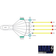
SplitMultiSeis 3D Technology is a 3D marine seismic survey fully adapted to solve engineering problems.

The combination of two sources in flip-flop mode and 4 16-channel streamers gives for 1 pass a strip of 16 m (8 inline with bin 1x2 m) with a multiplicity of 16.
Also, real-time quality control and primary processing of the received data is carried out on board the vessel in real time.
The fundamental factor in the success of three-dimensional shooting is the quality of navigation support for surveys.
The positioning of SplitMultiSeis devices is carried out using 4 towed navigation buoys and a base onboard station operating in differential mode. Thus, the navigational reference of towed devices with an accuracy of 0.25 m is provided.
The descent and lifting of equipment takes 40-60 minutes. Productivity - at least 0.25 sq. Km.

LLC "Split"
员工总数: 28
地点: Russia Moscow
主要产品/服务: Research and development of equipment in the field of marine geophysics and seismic acoustics
注册: Russia Moscow
成立年: 2011